The Loop Trail crossing a wooded bridge

The Fairfield Loop Trail

Sixteen-plus miles in ten connected segments encircle Fairfield — passing through woods, along three lakes, across historic railroad bridges, and over restored wetlands.

The Loop Trail officially begins and ends at Mile Marker Zero, next to the historic Maasdam Barns by the Jefferson County Health Center, at the interchange of Hwy 1 and US 34. Mile markers appear every quarter mile around the loop. Each segment below lists its length, surface, entry points, parking, and restrooms.

Plan your route. The interactive map below follows the actual trail path. Download the GPS track (GPX) to follow it on your phone, or print the Loop Trail & Parks Map (PDF).

Fairfield Loop Trail (16 miles) Maasdam Barns — Mile 0 (start / finish) ⤓ Download GPS track (GPX) ↗ View on AllTrails

Use it in your favorite app. The same GPS track (GPX) works in every major trails app — download it, then import:

  • Strava — on the web, go to Dashboard → My Routes → Upload GPX; the route then syncs to the mobile app.
  • Komoot — Plan a tour → Import GPX.
  • Gaia GPS, Ride with GPS, Garmin Connect — use each app's Import / Upload GPX option.
  • AllTrails — the trail already has a page on AllTrails with reviews, photos, and a map you can follow.
  • On most phones you can also tap the GPX link above and choose Open in… your app of choice.
1

Iowa DOT-South

5.7 miles · Crushed limestone

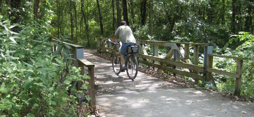
The longest segment of the loop, built by the Iowa DOT alongside the US Hwy 34 bypass. It runs from Mint Blvd in the east to Whitham Woods in the west — hilly, with curves, woods, and wetlands — and intersects the Cedar View Trail leading to Jefferson County Park and Libertyville. The trail begins and ends here at Mile Marker Zero by the Maasdam Barns.

  • Length: 5.7 miles
  • Surface: Crushed limestone
  • East entry: South Mint Blvd (south of Lamson Woods)
  • Hwy 1: Intersects State Hwy 1 / South Main St
  • West entry: Connects to the Whitham Woods segment
  • Parking: Maasdam Barns, Kale Blvd, Cedar View Trail, Whitham Woods
  • Restrooms: Maasdam Barns Museum & Cedar View Trail intersection
  • Nearby: Jefferson County Park, O. B. Nelson Park

Bonus loop: The Jefferson County Health Center's own 0.9-mile gravel walking trail circles its 34-acre campus right next to Mile Marker Zero, connecting to the Loop Trail on the south and east sides — a nice add-on lap around the hospital grounds. Read more from the Health Center →

2

Whitham Woods

1.2 miles · Lime chips & concrete

Uses part of an 1858–1901 railroad bed, then climbs and descends through the woods before following a concrete path along Burlington Ave to Brookville Road. The wooded section was upgraded and rebuilt in 2010, and now features a self-guided interpretive trail.

  • Length: 1.2 miles
  • Surface: Lime chips; concrete along Burlington Ave
  • West end: Connects to the DOT-South segment
  • East end: Trail bridge at Brookville Rd & Burlington Ave
  • Parking: Whitham Woods parking lot
  • Restroom: Whitham Woods parking lot
3

Northwest

2.2 miles · Mostly concrete

From Whitham Woods, this mostly-concrete segment heads northeast from Brookville Road, crosses the BNSF railroad track through a pedestrian safety maze, and continues to the Rock Island Railroad segment at 8th Street.

  • Length: 2.2 miles
  • Surface: Mostly concrete, some lime chips
  • West end: Brookville Rd at Burlington Ave
  • East end: 8th Street & Gear Ave
  • Restroom: Dexter Apache Soccer Park on Grimes Ave
  • Nearby: Dexter Apache Soccer Park, Heritage Park
4

Rock Island Railroad

1.3 miles · Crushed limestone

Follows the roadbed of the Rock Island Railroad (in use 1945–1980). The trail's Matkin Bridge replaces the railroad bridge that was removed in 1985.

  • Length: 1.3 miles (old railroad roadbed)
  • Surface: Crushed limestone
  • West entry: 8th Street & Gear Avenue
  • East entry: North B Street
  • Parking: Trail lot on the east side of the Matkin Bridge
  • Nearby: Heritage Park, Waterworks Park (Bonnifield Lake beach)

Bonus loop: Waterworks Park has its own walking trails around Bonnifield Lake that connect directly with the Loop Trail — an easy detour if you want a longer lakeside stroll.

5

B Street

0.4 miles · Concrete sidewalk

A short concrete sidewalk segment along B Street connecting the Rock Island Railroad segment to the Lakes segment. The sidewalk continues south to Waterworks Park and Stone Ave.

  • Length: 0.4 miles
  • Surface: Concrete (sidewalk)
  • North entry: North B Street (Rock Island RR segment)
  • South entry: North B St at Zimmerman Blvd (Lakes segment)
  • Parking: North B St at Zimmerman Blvd
  • Nearby: Waterworks Park, Bonnifield Lake
6

Lakes

2.25 miles · Crushed limestone

One of the most scenic segments, connecting three lakes — Bonnifield Lake, Pleasant Lake, and Walton Lake — as it meanders through fields and woods. These three retired reservoirs have been converted to recreation, with a native prairie along the way. Bonnifield Lake has a swimming beach; Pleasant Lake allows fishing and non-motorized boats.

  • Length: 2.25 miles
  • Surface: Crushed limestone
  • West entry: North B St at Zimmerman Blvd
  • Mid entry: Pleasant Plain Rd (Pleasant Lake)
  • South entry: Walton Rd, near Walton Lake
  • Parking: B St, Pleasant Lake, Walton Rd, Waterworks Park
  • Restroom: Pleasant Lake parking lot
7

Louden Bridge

1 mile · Crushed limestone

Travels through woods and crosses the BNSF Railroad on the 246-foot Louden Bridge into Chautauqua Park, where it meets the Crow Creek segment. The bridge displays 171 ceramic plaques of images from Louden Machinery Company blueprints, made by a Fairfield High School art class.

  • Length: 1 mile
  • Surface: Crushed limestone
  • North entry: Walton Road at Walton Lake Drive
  • South entry: Huggins Family Bridge, east Chautauqua Park
  • Parking: Walton Rd lot & Chautauqua Park
  • Restroom: Chautauqua Park, western end
  • Nearby: Chautauqua Park, community orchard & wetlands, Central Park (3/4 mi east on E. Broadway Ave), Howard Park (2 blocks north of Central Park)

Bonus loop: Chautauqua Park has its own paved loop road with good walking, connecting into the Loop Trail. It's shared with cars during the summer, but closed to vehicle traffic in winter — making it an especially good season for a quiet, car-free walk.

8

Crow Creek

0.6 miles · Limestone & concrete

Follows Crow Creek from Chautauqua Park to Glasgow Road. The concrete northern end gives way to crushed limestone through wooded lowland, where three volunteer-built bridges cross creeks on the Fry property. Cross Glasgow Road to enter the Lamson Woods/Neff segment.

  • Length: 0.6 miles
  • Surface: Crushed limestone; concrete at north end
  • North entry: Huggins Family Bridge, Chautauqua Park
  • South entry: Glasgow Rd & Middle Glasgow Rd
  • Parking: Chautauqua Park & small lot on Middle Glasgow Rd
  • Restroom: Chautauqua Park, western end
9

Lamson Woods / Neff Wetlands

0.4 miles · Boardwalk & limestone

Begins at Glasgow Road and heads west across the wetlands dike. The 326-foot Zillman Bridge boardwalk carries you to the Mint Blvd parking lot, with a walking-only trail branching off. Lamson Woods is an Iowa State Preserve; the adjoining Neff Wetland was donated in 2017 to the Jefferson County Conservation Board for environmental use.

  • Length: 0.4 miles
  • Surface: 326-ft Zillman Bridge boardwalk; rest crushed limestone
  • East entry: Glasgow Rd at Middle Glasgow Rd
  • West entry: E. Fillmore Ave & Mint Blvd
  • Parking: Lamson Woods lot, off Mint Blvd
  • Restroom: Lamson Woods parking lot
10

Mint Blvd Link

Connector · Closes the loop

The final connector runs along Mint Blvd, linking the western end of the Lamson Woods/Neff segment back toward the DOT-South segment near the Maasdam Barns — completing the loop and returning you to Mile Marker Zero.

  • Role: Connector closing the loop
  • Surface: Concrete sidewalk / on-street along Mint Blvd
  • North end: E. Fillmore Ave & Mint Blvd (Lamson Woods)
  • South end: South Mint Blvd (DOT-South segment)

Looking for quieter paths?

Beyond the Loop, Jefferson County has another 17+ miles of trails — including walking-only paths, railroad-bed trails, and nearby water trails.